
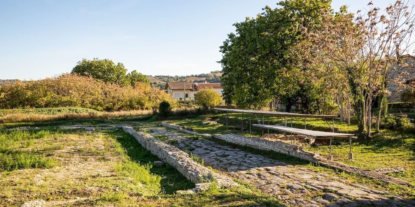

Sometimes Italy’s oldest and most precious layers resurface in hidden places far from mass tourism—timeless villages that still offer authentic, unfiltered glimpses of the past.
This is the case of our hidden archaeological route in the heart of the Marche region, in the province of Pesaro e Urbino, a remarkably well-preserved landscape where history and nature blend seamlessly.
From this unique interplay, the itinerary takes shape: 7 stages on a journey through Roman cities and ancient routes that still reveal the deepest essence of this extraordinary land.
A 7-Stop archaeological route through Marche’s oldest hidden treasures
🥇 Visit Italy’s brand partnership
To follow the thread of this story, we begin in Fano, the ancient Fanum Fortunae, a city that more than any other reflects the deep connection between this region and Roman civilization. This is where the ancient Via Flaminia first reaches the Adriatic Sea, setting the stage for a journey through some of the most remarkable historical landmarks in the Province of Pesaro e Urbino.
Each stop reveals a different chapter of this hidden archaeological route of Le Marche, from Pergola’s magnificent Gilded Bronzes to Fossombrone, Terre Roveresche, and Colli al Metauro, places deeply connected to the history of the Via Flaminia, before reaching Cagli and Cantiano, and then returning toward the coast to San Costanzo, through a landscape that still bears the marks of a millennia-old past.
To truly experience this route, it’s advisable to travel by car, as the stages do not follow a linear path. We’ll move across valleys and hills crossing the landscape freely and far from rigid itineraries, with the feeling of having no fixed destination.
The result is a journey that invites us to look at these places from a different perspective, following a story that comes together stop by stop and continues to leave its mark to this day.
Discover more about itineraries in Le MarcheStage 1. Fano, the Roman city that opens our Marche archaeological route
The first stop on our archaeological itinerary takes us to Fano, a city where the Roman heritage and more than two thousand years of history are still part of everyday life. For this reason, it's the perfect place to begin our journey.
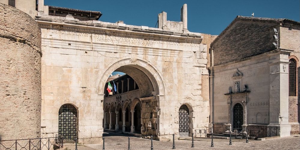
It’s impossible not to stop and admire the majestic Arch of Augustus, built in 9 AD as a monumental gateway to Fanum Fortunae. Then, once we reach the heart of the historic center, we can step into the fascinating Archaeological Museum and Art Gallery of Palazzo Malatestiano in Fano, where we find artifacts and artworks ranging from the Roman era to more recent centuries.
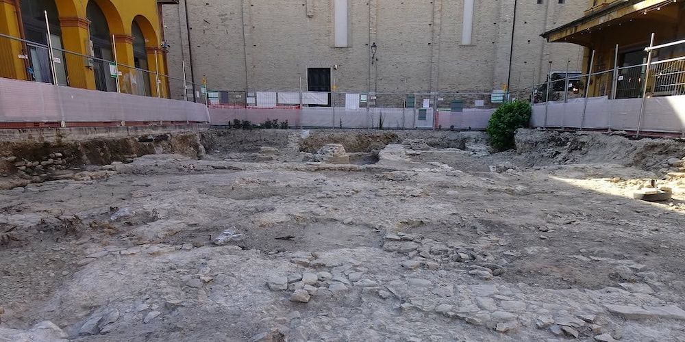
Not far away, we find one of the most important archaeological discoveries of recent years: the Basilica of Vitruvius. Identified during excavations carried out as part of the redevelopment of Piazza Andrea Costa, this structure corresponds with remarkable precision to the basilica described by the Roman architect Vitruvius in his renowned treatise De Architectura, and is considered the only building that can be attributed to the Roman architect with certainty.
Studies have made it possible to reconstruct a monumental rectangular building with a surrounding colonnade consisting of eight columns along the longer sides and four along the shorter sides. The size of the columns and their arrangement have confirmed the match with Vitruvius’ architectural model, making this discovery an extraordinary milestone that writes a fundamental chapter in the history of Fano and of ancient architecture.
How to get to Fano?
Fano lies on the Adriatic coast of the Marche region. We can reach it by car from both north and south via the A14 motorway (Fano exit). From Bologna, the drive takes under 2 hours (about 160 km).
What to see and do in Fano:
- Arch of Augustus;
- Archaeological Museum and Art Gallery of Palazzo Malatestiano;
- Remains of the Basilica of Vitruvius.
Stage 2. Pergola, home of the Gilded Bronzes
🥇 Visit Italy’s brand partnership
Leaving the Adriatic coast behind, let's head into the heart of the Province of Pesaro and Urbino to reach Pergola, a charming hill town that is home to one of Italy's most extraordinary archaeological discoveries.
It was here, in 1946, that a group of local farmers accidentally unearthed the remarkable Gilded Bronzes of Pergola, the only surviving Roman gilded bronze sculptural group ever discovered.
Today, we can admire them at the Museum of the Gilded Bronzes and the City of Pergola, where an engaging exhibition path reveals the secrets of this masterpiece of Roman art.
Since 2019, the display dedicated to the Gilded Bronzes has been transformed into an immersive exhibition room designed by physicist Paco Lanciano. The scholar is known for his scientific consultancy work for the television programs Quark and Superquark, and for the multimedia installations at the Roman Domus of Palazzo Valentini, the Forum of Augustus, and the Forum of Caesar in Rome.
Through videos and light effects, Lanciano’s multimedia experience places the Gilded Bronzes at the heart of the narrative, offering visitors a captivating journey through the history of the statues and the story behind their creation.
Our visit, however, should not end at the museum. As we stroll through Pergola's historic center, we discover an authentic and welcoming town where archaeology, culture, and everyday life blend seamlessly, preserving the timeless charm of the Marche countryside.
How to get from Fano to Pergola?
Pergola is about 45 km (28 miles) from Fano and can be reached by car in approximately 45–50 minutes, following the road that leaves the Adriatic coast and winds through the rolling hills of the Marche countryside, passing through Calcinelli, Pian di Rose, and Isola di Fano.
What to see and do in Pergola:
- Museum of the Gilded Bronzes and the City of Pergola;
- Pergola historic center.
Stage 3. Fossombrone: in the footsteps of the ancient Via Flaminia
🥇 Visit Italy’s brand partnership
Our next stop is Fossombrone, the modern-day successor to Forum Sempronii, one of the most important Roman towns founded along the Via Flaminia.
Here, we can uncover its rich past by exploring the Archaeological Park, the only site of its kind in the province of Pesaro e Urbino, where the remains of public and private buildings stand alongside original sections of the ancient Roman road. Walking on the same stones once crossed by merchants, travelers, and Roman officials heading to Rome is a truly unforgettable experience that brings the ancient world to life.
The archaeological site is located just outside the town. After our visit, we make our way into Fossombrone's beautiful historic center, which developed on Sant'Aldebrando Hill after the abandonment of ancient Forum Sempronii.
As we stroll along Corso Garibaldi—with its beautiful double arcade—we admire elegant Renaissance and Baroque palaces that tell the story of the city's evolution over the centuries. We should also make time to visit the remains of the Malatesta Fortress, where breathtaking views stretch across the Metauro Valley.
Finally, let's stop at the Bridge of Concordia, better known as the "Eye of Fossombrone," where we can enjoy one of the most picturesque views of the historic center.
How to get from Pergola to Fossombrone?
Fossombrone is just over 20 km (12 miles) from Pergola and can be reached by car in about 30 minutes. The route heads back toward Fano until the small village of Ghilardino, where we turn left onto State Road SS73bis. After just a few hundred meters, we'll arrive at our destination.
What to see and do in Fossombrone:
- Forum Sempronii Archaeological Park;
- Fossombrone historic center;
- Malatesta Fortress;
- Ponte della Concordia.
Stage 4. Terre Roveresche: a landscape of hilltop villages telling their own story
🥇 Visit Italy’s brand partnership
Leaving Fossombrone behind, we remain in the Metauro Valley as we enter Terre Roveresche, a group of small historic villages spread across the hills, each with its own identity and all connected by a shared network of history and settlements that has developed over the centuries.
This is a territory created in 2017 from the merger of four municipalities. Our exploration begins in Barchi, a perfect example of Renaissance urban planning—the so-called “ideal city” designed by Filippo Terzi—where the town layout still clearly reflects a precise geometric design.
A short distance away lies Orciano di Pesaro, with its ancient castle dominated by the Malatesta Tower and the church of Santa Maria Nuova. Not far from Orciano, we also visit the Rocca Roveresca, a majestic and remarkably well-preserved Renaissance fortress.
Let’s continue along the hills to San Giorgio di Pesaro, a village with a compact historic center, alongside cultural highlights such as the fascinating Environmental History Museum.
We end this stage in Piagge, where we can explore the fascinating Grotta Ipogea, an underground space carved beneath the historic center that reveals the ancient relationship between people and the hillside, and represents one of the most distinctive features of the Terre Roveresche municipality.
How to get from Fossombrone to Terre Roveresche?
This stage is a special one: we are not stopping in a single town, but moving through the hills, gradually encountering the villages that make up the heart of the Terre Roveresche. The first stop along the way is Barchi, about a 20-minute drive from Fossombrone.
What to see and do in Terre Roveresche:
- Barchi;
- Orciano di Pesaro;
- San Giorgio di Pesaro;
- Piagge.
Stage 5. Colli al Metauro: three villages around the great river
🥇 Visit Italy’s brand partnership
After Piagge, last village of the Terre Roveresche, we head down toward the Metauro valley, home to the longest river in the Marche region and one of the most beautiful rivers in Italy.
shaped by the longest river in the Marche region, described by Torquato Tasso as the “glorious son of the Apennines.”
Along this natural axis lies the territory of Colli al Metauro, where the three historic centers of Saltara, Montemaggiore al Metauro, and Serrungarina—now merged into a single administrative municipality—still preserve their distinct historical identities.
Montemaggiore al Metauro is the first village we reach along our route. Set in a dominant position above the valley, the historic center is reached by a staircase that leads up to the main square, opening onto wide views over the Metauro Valley and, in the distance, the Adriatic coast.
In Saltara, located shortly after crossing the river, we find a compact town shaped by stairways and passageways that lead up to the upper part of the village, where the Church of the Gonfalone stands. This historic building preserves important artistic works tied to the local tradition.
On the opposite side of the valley lies Serrungarina, a vertically developed hilltop village, marked by narrow streets and stairways that lead up to the main square, home to the evocative Church of Sant’Antonio Abate.
How to get from Terre Roveresche to Colli al Metauro?
From Piagge, it only takes a few minutes to reach Montemaggiore al Metauro. From there, we cross the river and continue up to Saltara. To reach Serrungarina, we return to the main road running along the Metauro and then turn right once we reach Tavernelle.
What to see and do in Colli al Metauro:
- Montemaggiore al Metauro;
- Saltara and its historic center with the Church of the Gonfalone;
- Serrungarina.
Stage 6. Cagli and Cantiano: the Via Flaminia at the heart of the Apennines
🥇 Visit Italy’s brand partnership
From Colli al Metauro, we follow the river valley upstream to enter the Umbrian-Marche Apennines. We pass through Fossombrone once again and continue beyond the spectacular Marmitte dei Giganti rock formations, near the Furlo Gorge Nature Reserve.
This landscape leads us to Cagli, one of the most important towns along the Apennine section of the Via Flaminia, located in a strategic position that connected Rome with the Adriatic coast for centuries.
The ancient Roman town of Cale was in fact a key point along the Roman road network, and today the area still preserves numerous traces of its past. We can visit the Archaeological and Via Flaminia Museum, housed inside the Palazzo Pubblico, where artifacts tell the story of the local area from prehistoric times to the Roman age.
Just outside the town center, it's also worth visiting the impressive remains of the Via Flaminia, including the remarkable Ponte di Mallio, which still demonstrates the extraordinary ability of the Romans to adapt their roads to the characteristics of the landscape.
From Cagli, we continue to Cantiano, a border town between Le Marche and Umbria at the foot of Mount Catria. Its ancient Roman name was Luceoli, and its connection with the Via Flaminia can still be seen in the town’s strategic location.
We can explore this history at the “G. C. Corsi” Archaeological and Via Flaminia Museum, located just a few steps from Piazza Luceoli, where artifacts related to ancient roads and Cantiano’s role as a stopping point along the route between Rome and the Adriatic are preserved.
Another fascinating testimony can be found at the Pontericcioli archaeological site, a few kilometers from the town, where stone structures connected to the Roman road system emerge within a landscape that has preserved its strong natural integrity.
How to get from Colli al Metauro to Cagli and Cantiano?
Cagli is about 35 km from Colli al Metauro and can be reached by car in around 30 minutes, following the Metauro Valley upstream and continuing toward the Apennine inland through the Gola del Furlo gorge. Cantiano is located about 10 km further upstream, requiring an additional 15 minutes by car.
What to see and do in Cagli and Cantiano:
- Cagli historic center and the Archaeological and Via Flaminia Museum;
- Ponte di Mallio and remains of the ancient Via Flaminia;
- Cantiano historic center and Piazza Luceoli;
- “G. C. Corsi” Archaeological and Via Flaminia Museum;
- Pontericcioli archaeological area.
Stage 7. San Costanzo: returning to the coast to close our archaeological journey
🥇 Visit Italy’s brand partnership
Cantiano is the most inland point of our archaeological itinerary. For the final stage, we head back toward the Adriatic coast, not far from Fano, to reach San Costanzo. This charming hilltop village lies between the Metauro and Cesano valleys, in a panoramic position overlooking both the sea and the inland hills.
The origins of San Costanzo are very ancient, dating back to the Iron Age, as shown by finds from the local Picene necropolis. Over the centuries, the settlement developed into a medieval fortified town, with steep lanes, arches, and stretches of defensive walls that still preserve the layout of its former fortification system.
In the heart of the historic center stands Palazzo Cassi, a noble residence that now houses the Quadreria and the Archaeological Room, preserving the artistic and historical memory of the town.
If you visit San Costanzo during the first Sunday of Lent, you can experience one of its most characteristic (and tasty!) traditions, the “Sagra Polentara.” These festivities also show how the town is an ideal place to end our archaeological journey across the coast, hills, and Apennines.
How to get from Cantiano to San Costanzo?
Let's return toward the Adriatic following the SS73bis almost to Fano, where signs for San Costanzo appear near the motorway exit area. The journey is about 67 km and takes just under an hour by car.
What to see and do in San Costanzo:
- Historic center;
- Palazzo Cassi;
- “Sagra Polentara” (first Sunday of Lent).
About the author
Written on 17/07/2026
Alessandro Savino
SEO Copywriter & web editor: I love transforming my passion for writing into engaging narratives, creatively and precisely exploring the beauty and complexity of our wonderful country.

Alessandro Savino
Set off in search of the hidden archaeological route of Le Marche: 7 stops to uncover the secrets of an ancient Italy, unexpected and striking.