
Olive trees covered in white blossoms, villages coming back to life, the call of the sea. This is spring in Southern Italy, the most authentic atmosphere to immerse ourselves in a journey that blends silence and nature: Southern Via Francigena.
From Troia to Santa Maria di Leuca, where the Adriatic and Ionian Seas meet and almost touch, we set off to discover villages, white country roads, and breathtaking landscapes that shift with the rhythm of our steps.
Are you ready? Here are the 12 stages of Via Francigena that will lead us to the sea, opening our eyes to the wonders of the South.
Why choose the Apulian stretch of the Via Francigena in spring: 12 stages from Daunia to the Heel of
🥇 Visit Italy’s brand partnership

This section of Via Francigena, from the Daunia region to Santa Maria di Leuca, reveals its most captivating side in spring. Temperatures are mild, the days grow longer, and walking through the Apulian countryside becomes a genuine pleasure.
Choosing this route in this season also means experiencing a more authentic dimension of your journey, with less crowded trails and, in general, a more direct and genuine form of hospitality.
From a practical point of view, this stretch of Via Francigena can be approached in different ways: the official stages are numerous and designed for a complete, long-distance walk, but you can also build a shorter, more streamlined (and more demanding) itinerary, like the 12-stage version we propose here. The final choice always depends on the time available and your own pace.
It's also a perfect trip for those approaching Via Francigena from Rome. The most practical access point to the Daunia region is the historic town of Troia. From Rome, you can reach Foggia by train in about three hours, then continue to Troia by bus or car in around 45 minutes.
From there, the real walk begins, heading south. The goal: reaching the point where two seas meet near the Heel of Italy, around Santa Maria di Leuca.
The landscapes of Apulia we will cross:
- Daunia;
- Tavoliere delle Puglie;
- Murge;
- Salento.
Discover more about Via FrancigenaStage 1. Troia → Ordona: first breaths of the Via Francigena

Let's leave behind the historic core of Troia, with its striking Romanesque cathedral, and gradually enter a more rural dimension, a farming landscape where small settlements alternate with cultivated fields and stretches of open countryside.
In spring, the fields turn shades of green as you walk along flat gravel roads that naturally help you find a steady rhythm from the very beginning.
Castelluccio dei Sauri marks the first intermediate stop, while Ordona closes the stage after just over 40 km.
From this first stretch of the Daunia region, the Southern Via Francigena network also allows detours and connections towards the Gargano and the northern inland areas, with variants leading to remarkable places such as Monte Sant'Angelo, one of the most important spiritual sites in the region.
What to see and do:
- Historic center of Troia;
- Agricultural landscapes of the Daunia region;
- Passage through the rural villages of Castelluccio dei Sauri and Ordona;
- Possible connections towards the Gargano and Monte Sant’Angelo via the Southern Via Francigena network variations.
Stage 2. Ordona → Cerignola: walking across the Tavoliere

We enter the Tavoliere delle Puglie, a landscape made of long agricultural roads, sunlit stretches, and small settlements that appear like oases within an endless rural horizon.
Compared to the previous stage, the sense of space here expands noticeably. You are no longer in the more compact countryside of the Daunia, but in a continuous plain where the eye can travel far without interruption and where landmarks become increasingly rare along the route.
It’s only upon reaching Cerignola, after about 38 km, that a clear shift becomes noticeable. The countryside gives way to a more structured urban setting, marking the first major town and a key urban centre of our journey.
What to see and do:
- Crossing the Tavoliere delle Puglie;
- Wide agricultural landscapes and seasonal crops;
- Arrival in Cerignola, a historic town linked to the agricultural identity of the area.
Stage 3. Cerignola → Canosa di Puglia: between plains and archaeology

We are now in the historic and layered landscape of northern Murgia.
This stage is shorter than the previous ones, around 20 km, and for this very reason it gives you time to slow down, observe, and let yourself be surprised. Leaving behind the open expanses of the Tavoliere, the countryside gradually begins to change, with the first gentle hills appearing as you approach Canosa di Puglia.
Canosa, one of the oldest towns in the region, has more than 3,000 years of history. Beneath the surface lies a network of underground funerary hypogea — tombs carved into tuff stone, decorated with frescoes and burial objects. The Roman Bridge over the Ofanto River and the Arch of Trajan are some of the traces left by this remarkable past.
Since the stage is shorter, we can take our time exploring the historic center, visiting the National Archaeological Museum, the Lagrasta and Scocchera B hypogea, the Baptistery of San Giovanni, or the Mausoleum of Bohemond.
What to see and do:
- Entrance into the northern Murgia landscape;
- Historic center of Canosa di Puglia: National Archaeological Museum, Ancient funerary hypogea, Baptistery of San Giovanni and Mausoleum of Bohemond.
Stage 4. Canosa di Puglia → Andria: towards the lands of Frederick II

From Canosa di Puglia, it takes around 24 km to reach Andria, following a more undulating landscape that signals how deeply we are entering the Murge region. In spring, the fields fill with green shades and wildflowers, while the route gently rises and falls among ancient olive trees and isolated masserie, creating one of the most contemplative stretches of the Apulian Via Francigena.
If you are cycling this stage, you can take a detour of about 17 km towards Castel del Monte, the UNESCO-listed octagonal castle commissioned by Federico II, ruler of the Holy Roman Empire, who left some of the most important traces of his reign across Apulia.
Once in Andria, we can visit the Cattedrale di Santa Maria Assunta, home to the tombs of two of Frederick’s wives. The historic center is also the perfect place to pause and taste some of the city’s iconic local products, especially fresh burrata cheese.
What to see and do:
- Rolling landscapes of the Murge;
- Castel del Monte;
- Andria: Cattedrale di Santa Maria Assunta and historic center;
- Burrata and local food specialties.
Stage 5. Andria → Ruvo di Puglia: Apulia of the Coratina olive trees

Between Andria and Ruvo di Puglia the landscape loses the more pronounced hills of the previous stages and settles into a flatter, more regular countryside. This is a less varied stretch of Via Francigena, with long exposed sections and very little shade.
But despite this, you should not expect a monotonous stage.
The territory has a distinct rural charm: dense, well-ordered Coratina olive groves, red soil that sticks to your shoes, restored dry-stone walls, and the continuous presence of farm entrances and agricultural estates along the route.
The arrival in Ruvo di Puglia after 26 km marks the return to a more compact urban setting, with a light-stone historic center that still preserves the slow rhythm of inland Apulia.
What to see and do:
- Coratina olive groves and the agricultural landscape of the Murgia;
- Dry-stone walls and masserie along the route;
- Historic center of Ruvo di Puglia.
Stage 6. Ruvo di Puglia → Bari: towards the Adriatic coast

We leave the inland Murgia behind and walk towards Bitonto, nearly 20 km away, before continuing on to Bari, another 23 km further south.
This stage feels more urban than the previous ones, crossing residential districts, commercial areas and the expanding outskirts of the cities. Even so, you can still experience the charm of a living, authentic Apulia, with roads lined by yellow broom flowers and blooming rosemary, while the spring air gradually begins to carry the scent of the nearby sea.
In Bitonto we stop for a midday break, because its historic center is considered one of the best preserved in the region. Take the opportunity to try a plate of fresh orecchiette before the final stretch towards Bari.
The regional capital welcomes us with its Adriatic waterfront, the district of Bari Vecchia and the Basilica of Saint Nicholas, where the relics of Saint Nicholas are kept. During the Middle Ages, many pilgrims stopped here before embarking towards the Holy Land.
What to see and do:
- Transition from inland Murgia landscapes towards the Adriatic coast;
- Bitonto: historic centre and local cuisine;
- Bari: Adriatic waterfront, Bari Vecchia and the Basilica of Saint Nicholas.
Stage 7. Bari → Monopoli: on the way to Salento

From Bari, we follow the Adriatic coast towards Monopoli, a long stage of around 52 km that combines two official sections of Via Francigena. If you prefer a slower pace, you can easily split it into two days: Bari–Mola di Bari and Mola di Bari–Monopoli.
We walk along white roads with the sea always visible — or at least close by — while the coastline fills with shades of green from scattered pine groves, aromatic junipers and centuries-old olive trees. The landscape alternates between ravines, low cliffs and hidden coves.
In Mola di Bari you’ll find a historic harbor and an atmosphere still deeply connected to fishing traditions. It's the perfect place to stop for fresh seafood before continuing south.
Monopoli, today’s final destination, is one of the most characteristic coastal towns along the Apulian Via Francigena: a whitewashed historic center with narrow alleys, stone churches and the Castle of Charles V overlooking the Adriatic Sea.
What to see and do:
- A 52 km stage that can be divided into two days
- Adriatic coastline with the sea always nearby
- Mola di Bari: harbor and fishing traditions
- Monopoli: Castle of Charles V and historic center
Stage 8. Monopoli → Savelletri → Torre Canne → Torre Santa Sabina: the roads along the coast

The first stretch of this 8th stage takes us to Savelletri, just over 20 km away. Then, we continue towards Torre Canne for another 9 km, before tackling the longest section towards Torre Santa Sabina, 30 km south. Altogether, this makes nearly 60 km — one of the most demanding days of your journey.
Today, the focus is on the roads themselves. Quiet paved lanes alternate with dirt tracks winding through centuries-old olive groves and vineyards. The terrain is mostly flat, with gentle undulations, while spring brings the scents of Mediterranean scrub.
The sea is always close, while villages become rarer, and the natural pauses along the walk are farmhouses, country roads and isolated beaches.
If you have more time, you can easily divide this stage into two days, stopping overnight in Savelletri or Torre Canne.
What to see and do:
- A 60 km stage between Monopoli and Torre Santa Sabina, divisible into two days;
- Centuries-old olive groves, vineyards and blooming Mediterranean scrub;
- The constant presence of the Adriatic Sea through its sounds and scents.
Stage 9. Torre Santa Sabina → Brindisi: the final stretch of the Via Traiana

From Torre Santa Sabina we resume the walk along one of the most linear sections of the Apulian Via Francigena: just over 30 km following the coast towards Brindisi.
Along the way we cross the Torre Guaceto Nature Reserve, which introduces one of the wildest landscapes of the entire journey: dunes, Mediterranean scrub, pine forests and sandy paths where the sound of the waves accompanies the walk.
It's a physically easier stage in terms of elevation, and shorter than the previous two days. In spring, the sea breeze makes the walk even more pleasant, while the coastline remains quiet and far from the summer crowds.
The arrival in Brindisi is highly symbolic: this is where the Roman Via Traiana once ended, and from here, as in Bari, pilgrims would set sail towards the East.
What to see and do:
- Torre Guaceto Nature Reserve;
- Arrival in Brindisi, ancient terminal of the Via Traiana.
Tappa 10: Brindisi → Lecce: abbeys and Baroque

This 46-km stage takes us to Lecce, passing through Torchiarolo.
The route leaves the sea and bends slightly inland. The first part is demanding: as we exit the city we walk along busy roads, and moving away from the main urban area we leave the asphalt behind to return to green areas and olive groves.
Just before Lecce, with a short detour from the Via Francigena route, we find the Abbey of Santa Maria di Cerrate. Once a Byzantine monastery, today it's a unique example of Apulian Romanesque architecture with Byzantine frescoes and a striking, atmospheric setting.
Arriving in Lecce, the most important historic centre of Salento, we are welcomed by the City of Baroque. It’s impossible not to get lost among the façades of its emblematic buildings, such as the Cathedral and the Basilica of Santa Croce.
Before leaving, try the “pasticciotto leccese”, the city’s traditional sweet pastry.
What to see and do:
- Salento countryside;
- Abbey of Santa Maria di Cerrate;
- Baroque historic center of Lecce.
Stage 11. Lecce → Otranto: a frontier city

Otranto, the easternmost town in Italy, marks one of the most symbolic points of Southern Via Francigena. Reaching it from Lecce requires 60 km of walking: it's a long stage that can also be split into two parts, with a stop around Martano for those who prefer a slower pace.
Up to Martano, the route follows the Salento plain, where in spring the landscape turns intensely green, filled with the unmistakable scents of Mediterranean scrub. From there, the path gradually bends back towards the Adriatic coast, opening into a scenery of bays, headlands, beaches and natural landscapes.
Arriving in Otranto feels like entering a frontier city, overlooking the strait of the same name, with the Aragonese Castle dominating the harbour. This has historically been a gateway and a defensive stronghold, a crossing point between different worlds —the Adriatic, Greece, the Balkans and the eastern Mediterranean.
What to see and do:
- 60 km stage from Lecce to Otranto, divisible with a stop in Martano;
- Salento plain up to Martano;
- Otranto: Aragonese Castle;
- Frontier atmosphere between western and eastern Mediterranean.
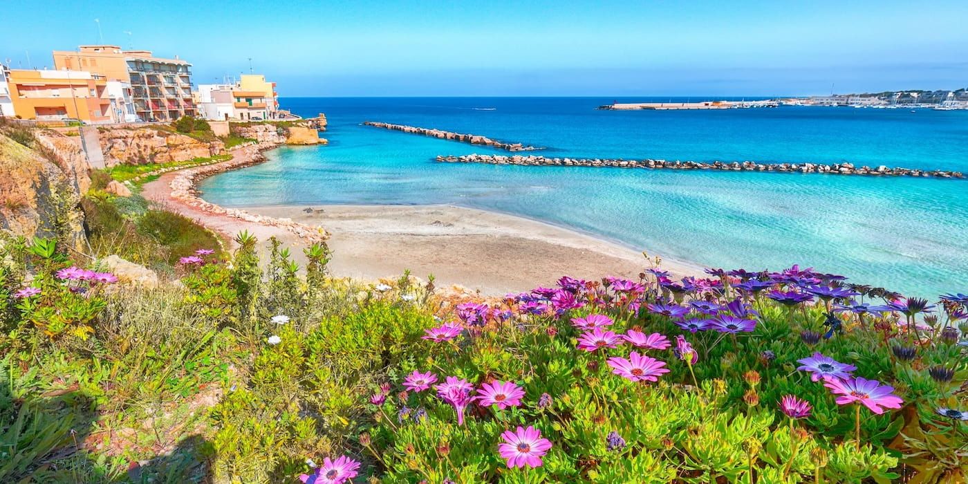
Tappa 12. Otranto → Santa Maria di Leuca: the Heel of Italy

The final stage is demanding: over 50 km along a route that accompanies us step by step toward Santa Maria di Leuca, the “heel” of Italy, where the Ionian Sea and the Adriatic Sea meet.
In the first part of the walk, between Otranto and Tricase, we follow secondary roads crossing the Salento inland: dense olive groves, dry-stone walls, and long exposed stretches under the sun.
We pass through Vignacastrisi and Tricase, quiet villages that offer good places for short breaks. At this point, however, we are carried forward by adrenaline and the awareness of being close to the final destination.
And finally, we reach Santa Maria di Leuca, where the Sanctuary of Santa Maria de Finibus Terrae and the lighthouse mark the southernmost point of Puglia. White cliffs drop sharply into the sea, and the horizon seems to lose its limits.
Our itinerary ends here. In 12 stages we have crossed a sequence of unique landscapes: from the Daunia to the Tavoliere, from the Murge to the Salento, through the scents of spring in a journey that has brought together history, nature, and spirituality in the authentic atmosphere of Via Francigena.
What to see and do:
- Salento inland landscape;
- Santa Maria di Leuca, Sanctuary of Santa Maria de Finibus Terrae and lighthouse.
All the Via Francigena stages in Apulia

The Via Francigena of Southern Italy crosses Apulia through a network of official stages that is far more detailed than the 12-day itinerary we have just explored.
What we chose instead is a more compact and demanding route, designed for those who want to experience the pilgrimage in spring by combining several official stages into longer walking days.
Below, you can find the complete list of the official Via Francigena stages in Apulia, from Troia to Santa Maria di Leuca:
STAGE → KM
1. Troia → Castelluccio dei Sauri — 23.7 km
2. Castelluccio dei Sauri → Ordona — 19.8 km
3. Ordona → Stornara — 20.3 km
4. Stornara → Cerignola — 17.9 km
5. Cerignola → Canosa di Puglia — 19.2 km
6. Canosa di Puglia → Andria — 24.0 km
7. Andria → Corato — 13.8 km
8. Corato → Ruvo di Puglia — 12.2 km
9. Ruvo di Puglia → Bitonto — 19.6 km
10. Bitonto → Bari — 23.8 km
11. Bari → Mola di Bari — 23.3 km
12. Mola di Bari → Monopoli — 29.0 km
13. Monopoli → Savelletri — 21.0 km
14. Savelletri → Torre Canne — 9.0 km
15. Torre Canne → Torre Santa Sabina — 29.7 km
16. Torre Santa Sabina → Brindisi — 34.4 km
17. Brindisi → Torchiarolo — 25.0 km
18. Torchiarolo → Lecce — 22.5 km
19. Lecce → Martano — 30.6 km
20. Martano → Otranto — 30.5 km
21. Otranto → Vignacastrisi — 25.9 km
22. Vignacastrisi → Tricase — 13.6 km
23. Tricase → Santa Maria di Leuca — 18.0 km

About the author
Written on 22/05/2026
Alessandro Savino
SEO Copywriter & web editor: I love transforming my passion for writing into engaging narratives, creatively and precisely exploring the beauty and complexity of our wonderful country.

Alessandro Savino
Let’s begin a slow journey along Via Francigena in Apulia: 12 stages from Troia to Santa Maria di Leuca into the magic of the South in spring.