
Traveller, your footprints are the path and nothing more; Traveller, there is no path, The path is made by walking.
EXPERIENTIAL TRAVEL

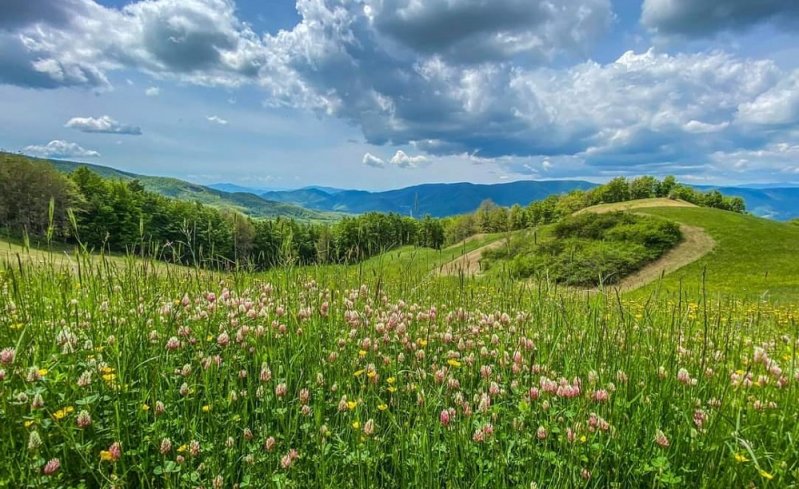
Whether you are an experienced trekker or a first-time walker, the Path of Gods is a unique experience, a journey through nature and into yourself that you will never forget. You will put your boots on a road that millions of people have trodden before you over the centuries, starting with the Etruscans in the 7th century BC. Under the leaves of thousands of autumns, you will continue to see the traces of all this humanity: mule tracks, kilns, ancient aqueducts, abandoned monasteries, hidden villages and toponyms that tell mysterious stories. While you are walking through villages and plantations, you can stop and talk to the locals. They are eager to tell you the story of their corner of the world and to suggest small detours. They help you to discover secret and unmissable places and to show you the most spectacular panoramic spot. They can also indicate the tavern, where to eat the best ravioli: visiting minor tourist sites is the way to help the territory to stay alive. Talk to other walkers you meet along the way, compare experiences, exchange travel tips and give each other courage before starting the umpteenth climb. The human contact with other walkers and locals will make the difference between a type of tourism that is just moving from one place to another and living a valuable experience that you will carry with you all your life.
It is not good for the spirit to imagine the destination with coffee in mind. You must learn to trust the path without putting in your backpack too many expectations because you have to take the tent down every morning, and the future is a strip of land in the middle of the ocean where you can only balance yourself by walking.
It is not good for the spirit to imagine the destination with coffee in mind. You must learn to trust the path, without putting in your backpack too many expectations, because the tent must be taken down every morning and the future is a strip of land in the middle of the ocean where you can only balance yourself by walking.
PREPARE THE BACKPACK AND PLAN THE ROUTE

The Path of Gods is not a very difficult trek; however, it is a mountain route with many ascents and descents, and as it takes place almost entirely within the woods, it is important to choose the stops well. Remember that the most important thing is not to arrive quickly at the end but enjoy the walk, so our advice is not to exaggerate with the kilometres per day, maybe include an extra stage and take your time to stop and admire the view and take photos. It is essential to find your pace, your style. The mountain has its own rules; you must find yours. Always try to start walking early in the morning so you can manage better your day: if you arrive at your destination a little earlier, you will have more time to rest, process your experience, study the route for the next day and perhaps enjoy a well-deserved aperitif! Along the Path of Gods there are many places where you can overnight (camping, B&Bs, guesthouses, hostels), but we recommend booking in advance, especially during the high season.
In the mountains, it is important not to underestimate the weather. We suggest you to avoid the most extreme temperatures.
The best months to set out on are May, June, September and October, but this does not guarantee that you will not be walking in a downpour or dipping your boots in the mud; in this case, remember the boy scout motto: bad weather does not exist, only bad equipment!
So, what should I carry in my backpack? Let's find out together!
• Water bottle
• a hot drink in winter
• anorak or k-way suitable for the period
• thermal blanket
• hat or cap
• protective cream
• mini first-aid kit (bandages, plasters of various sizes and anti-blister plasters, disinfectant wipes, sterile gauze, scissors, tick pliers, latex gloves, medicines...)
• a frontal torch
• Possible change of clothing depending on weather conditions.
• Mobile phone and charger
• Maps of the area
• Travel snacks
We recommend a 30L backpack and a fanny pack for frequently used items.
SIGNAGE AND CREDENTIALS

We recommend getting a map of the area when preparing your trip, so that you can get an idea of the differences in height and the types of roads you will encounter. If you have any doubts about the route, weather conditions and viability of the trail, please contact the Bologna and Florence sections of the CAI (Club Alpini Italiani).
The Path of Gods is very well signposted along the entire route by two types of signs, the main and the secondary ones.
The main signage is vertical and consists of signs placed at the start of the trail and at the most important crossings containing information on the locations indicating the name and altitude of the starting point or destination locations with the walking time and trail number. Secondary signage is horizontal and consists of white-red painted signs usually painted at the start and along the path, on stones or plants, used to provide information on continuity and confirmation of the route.
We strongly advise you don't rely on your mobile phone for orientation. Most of the paths are not marked on Google maps, and there are many shady areas in the mountains where internet connection (wi-fi) doesn’t work: use the directions on the maps and the signs to find your way around, you can't go wrong!
The Credential, if you wish to purchase it, is a sort of "pilgrim's passport", the vademecum of the journey: along the route you will find a personalised stamp in each affiliated establishment with which you will have to fill in the Credential, as proof and reminder of the journey. At the end of the journey, you can go to one of the authorised points to collect the free "Official Souvenir" of the Path of Gods.
The Apennines are anything but pure, the bastard child of earth gods, while the Alps are a celestial offspring of Olympian and dazzling Gods and their totem animals are agile and light: the eagle, the chamois, the ibex. The backbone of Italy, on the other hand, is the kingdom of the wild boar, which rolls in the mud and roosts at dusk, in search of tubers and roots.
THE STAGES

As mentioned above, we encourage you to create your own itinerary by organising stages with the travel times that suit you best. Below is an example of a journey lasting about a week. Obviously, the route can also be travelled in the opposite direction, from Florence to Bologna.
Stage 1 - Bologna / Badolo (23 km, difference in altitude 750m)
")
The path starts in Piazza Maggiore in Bologna, passes through the Arco del Meloncello and leads out of the urban circle through one of the 12 city gates. From here you will begin the porticoed route leading to the Sanctuary of San Luca (the 666 arches leading to the sanctuary make San Luca's the longest portico in the world). Continue towards Parco della Chiusa and the footbridge over the river Reno to the Vizzano cemetery. You will note at this point that there are two types of routes: one for mountain bikes and one for walkers. In both cases you will reach Sasso Marconi and after about an hour and a half's walk you will pass through Nova Arbora (where there is a beautiful botanical garden): at this point you will have less than 2 kilometres left to Badolo.
BEFORE LEAVING ON THIS WONDERFUL TOUR, DON'T MISS BOLOGNA'S ATTRACTIONSStage 2 - Badolo / Madonna dei Fornelli (28 km, difference in altitude 1100m)
")
Once you take the path leading to Monte del Frate, you will soon pass a small valley, from where the ascent to Monte Adone begins during the trekking you may see rust-coloured bomb fragments from the Second World War, recognisable by the iron stains they leave on the ground, and many fossil shells. Once at the top, look and sign the summit notebook. The second climb of the day is to Mount Monterumici, where you can see the trenches dug by the Germans to defend the Gothic Line. From here on, as far as Madonna dei Fornelli, you will encounter several small villages and woods of poplars and chestnut trees.
Stage 3 - Madonna dei Fornelli / Passo della Futa (17 km, difference in altitude 580m)
")
From Madonna dei Fornelli the real mountains begin, thicker woods, sparser houses, silence, wild and solitary landscapes. Through dirt roads and fir woods we reach the border separating Emilia-Romagna from Tuscany. At this point there are signs to follow the Roman road to magnificent Capannoni meadows: once you have passed the farmhouse, turn left and continue to Piana degli Ossi where you can see some Roman kilns for producing lime. Continue through the beech woods until you reach the top of Le Banditacce. From here on, you will find many signs indicating the ancient Via Flaminia Militare. The Germanic Military Cemetery will clearly indicate your arrival at the Passo della Futa. In 1955, ten years after the end of the war, Italy and Germany signed an agreement for the burial of German soldiers who had fallen on Italian territory. More than 32,000 soldiers of the Wehrmacht were buried at the Futa Pass under 16,000 granite slabs and 12 hectares of meadow. A sign reminds us that the graves of the fallen are the great preachers of peace.
Stage 4 - Passo della Futa / San Piero a Sieve (27km, difference in altitude 770m)
")
On this stage of the Path of Gods, you will enter a real Arboreal Cathedral: chestnut trees, beech trees, fir trees, broom and thorny prunus will accompany you throughout your walk. Take the rock and clay path to the Osteria Bruciata (burned tavern) pass: this is a crossroads of ancient roads that became Etruscan paths, road unknown by the Romans: the Roman Flaminia Miltirare road, follows the Futa road a few kilometres away. It is said that Hannibal passed through here in 217 BC with the only elephant that survived at winter. During the struggles between the Guelphs and Ghibellines, the pass was controlled by the Ubaldini family, fierce adversaries of the city of Florence: perhaps it was the Florentines who spread the rumour that the Osteria del Vecchio Passo was not very welcoming, and that the wayfares risked being fed with a boiled human meat dish, before ending up in the frying pan themselves. Now almost nothing remains of the old Osteria except a triangular stone commemorating its existence. From here, the descent towards Sant ‘Agata is very well signposted, but we recommend a small diversion to the Bosco dei Frati convent: a very evocative place in the middle of the woods, the setting for many legends about St Bonaventure. From here you cross the Schifanoia estates to reach San Piero a Sieve where, if you still have energy to spare, we recommend a visit to the parish church and the Medici's mediaeval fortress.
Stage 5 – San Piero a Sieve / Bivigliano (15km, difference in altitude 900m)
")
You will continue into the Mugello valley and you won't struggle to recognise the typical Tuscan landscape characterised by tall cypresses, olive trees and the first umbrella-shaped maritime pines that anticipate the Maremma. If you happen to be around here on a Sunday, it is almost certain that you will hear the buzz of motorbikes whizzing along the Mugello circuit during the MotoGP season. During this stage you will tackle two of the most challenging climbs on the Path of Gods: the first one to the Badia del Buonsollozzo and the second one to Monte Senario. The Badia del Buonsollazzo is a grandiose monastery dedicated to Saint Bartholomew where only the cypresses are in good health and everything else is in ruins. Legend has it that it was founded before the year 1000 by Hugh the Great who got lost in these woods and vowed to build an abbey there if he survived. It has now been unused for at least 30 years and its ruins retain an undoubtedly decadent charm. The ascent to Monte Senario is preceded by a sign which reads: AFTER THE PURGATORY, ADMIRE THE PARADISE. In fact, the cedar forests frame a steep mule track, perhaps the most demanding climb of the entire route: 600 metres of difference in height to be covered in 7km. At the top you will find the Santuario del Senario, and you can refresh yourself with the excellent beers produced by the monks and with their herbal distillate "Gemma d'Abeto", which will give you a vigorous burst of warmth and energy: your legs will continue to walk on their own on the descent towards Bovigliano
Stage 6 – Bivigliano / Firenze (20km, difference in altitude 300m)
")
Leaving Bovigliano, after a few kilometres you reach Vetta alle Croci, which, in the opinion of the writer, is the most spectacular place on the entire Path of Gods and one of the most incredible panoramas in all Italy. You are at high altitude, immersed in breezy meadows studded with daisies, and in front of you, along the horizon line, two low hills open like a curtain on the beautiful city of Florence, recognisable from here by the subtle silver tongue of the Arno and Brunelleschi's majestic dome. When you are ready to leave this breathtaking panorama, you can continue to the top of Poggio Pratone which offers a beautiful view and from there descend towards Fiesole. At this point you will have left the woods and nature behind you and re-immersed yourself in villages and tarmac roads, but this regret will be repaid by the incredible views of Florence that will become more numerous as you descend from the hills towards the city. The last few kilometres will take you to Piazza della Signoria, the last stop on your journey, where you will take the customary photo together with other backpackers who have shared this incredible experience with you.
BOOK HERE YOUR ATTRACTIONS IN FLORENCEAbout the author
Written on 13/06/2021
Gloria Venturini
Travel agent, writer and web editor. Of all the books in the world, the best stories are found between the pages of a passport.

Gloria Venturini
The Path of Gods is an exciting multi-stage itinerary to discover one of the most beautiful areas of the Apennines. You can enjoy breathtaking landscapes, literally walk on ancient Etruscan roads, immerse yourself in the green woods and taste typical products and Tuscan-Emilian hospitality.