
Covid-free holidays: the trekking routes
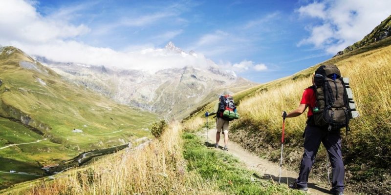
The exhausting series of prohibitions dictated by the pandemic led us to get used to the idea of covid-free holidays. Luckily, Italy is a versatile country, where you can wander with imagination in the search for things to do and places to visit in full compliance with the anti-Covid security rules. Among the most sought after experiences for this year, we find trekking routes:
-it is an outdoor experience;
-it takes a minimum risk of crowding;
-it avoids travelling by public transport.
In addition, trekking routes are a valid alternative to classic holidays, giving the taste of discovery typical of new experiences.
The path that we point out does not stop at a single region, nor a single portion of the Italian territory. The CAI path is the only trekking route that binds all the Italian Regions. That is why it is known as the Italian Way of St James.
Here is everything you need to know about it!

«The project Sentiero Italia represents our dream to connect the whole of Italy through a walk embracing the extraordinary territories that our country can offer far from the asphalt road».
The Sentiero Italia CAI (SICAI)
")
At the beginning of the '1980s, a group of friends - all experts in hiking - came up with the idea of creating a unique path that connects the main features of the vast Apennine routes already existing. In the 1990s, the newspaper "La Repubblica" reported the Sentiero Italia (SI) as a new important project and, with the support and collaboration of the Central Hiking Commission of the Italian Alpine Club (Italian acronym CAI), the concrete realization of the Sentiero Italia CAI (SICAI) began later in those years. Hundreds of CAI volunteers scattered throughout Italy set to work, and in 1995 the first Camminaitalia took place. Covering over 6000 kilometres of length from Sardinia to Friuli Venezia-Giulia, thousands of trekking enthusiasts and volunteers took part in an 8-months walking. According to CNN, it was the longest walk in the world.
With its 7200 km, the Sentiero Italia develops along about 500 stages and covers the entire Apennine ridge - including islands - and the southern slope of the Alps. Currently, almost the whole route is marked with the colours white and red and the acronym SI.
What is more, the SICAI is paving the way to make the excursion passable by bike and accessible by disabled people.
There is no need to be trekking experts to undertake the SICAI route. Nevertheless, it is not advisable to aggregate several stages without prior preparation to gradually improve one's resistance to fatigue and become familiar with the alpine and Apennine environment.
Moreover, it is essential to note that not all stretches are easily passable. For this reason, next to the indications of travel time, there are four letters used as abbreviations for:
-a pedestrian route that runs along wide paths and does not present orientation problems or particular fitness for physical effort (T=Tourist);
-paths that wind along slopes even quite inclined but still allow a safe and quiet pitch (E=Hikers). The "E" routes represent most of the SICAI stretches;
-challenging hiking trails, marked by very steep slopes and stretches of road on slippery terrain that require a strong sense of balance (EE=Expert Hikers);
-routes equipped with cables and chains. These are traits that require adequate preparation and expertise in the use of self-belaying devices (EEA= Expert Hikers with Equipment).
Along the way, it is possible to stay overnight in a tent (previously finding out about the chosen territory) or at the network of refreshment and reception points that the SICAI is expanding. At the moment, all available facilities are marked on the official map of the path.
The SICAI stages

Each Italian region has a unique territory. Walking through noiseless landscapes in uncontaminated nature is an incomparable experience.
Here, we will report one stage per Northern, one per Central, one per Southern and one per insular Italy to give you just an idea of the stunning beauties the SICAI offers.
• Northern Italy - Liguria
SICAI in Liguria has 22 Apennine stages and 12 Alpine stages, up to the Ligurian-Piedmontese border. The views are breathtaking and offer a stretch of the Ligurian landscape rich in ancient and recent history, unknown to seaside tourists.
-STAGE: (SI G30) Colle San Bartolomeo - Passo di Prale
This short stage climbs from Colle San Bartolomeo to the top of Monte Armetta, the highest peak of the Ligurian Prealps. From the top, you can enjoy a spectacular view of the border between Piedmont and Liguria. Descending from the mountain, you cross the thick woods of the Passo delle Prale that connect the two pretty towns of Caprauna and Ormea, in the province of Cuneo, both immersed in a majestic uncontaminated landscape. Caprauna is famous for the several sites where to practice rock climbing, while in Ormea parks and gardens, you will find sculptures made with the precious black marble typical of the city.
• Central Italy - Lazio
Lazio hosts 20 SICAI stages that wind through the Apennine mountain ranges of the Ernici Mountains, the Simbruini, the Carseolani Mountains and the Cicolano Mountains. The route reaches the historic Leonessa city, Cittareale, Torrita and Amatrice, sadly famous for the violent earthquake that destroyed most of the town in 2016.
-STAGE: (YES 03) Prato di Campoli - Certosa di Trisulti
This medium-length stage locates in the Ernici Mountains. Going up the thick woods towards Vallone Femminamorta, you reach the foot of Mount Ginepro. By following the route, you get to the Certosa di Trisulti, an ancient Benedictine monastery surrounded by forests of majestic oaks at 825 m above sea level. Here, you can visit the Church rich in terrific works of art, the gardens and the ancient Pharmacy decorated with realistic trompe-l'œil, a pictorial technique creating the illusion of looking at living and three-dimensional objects, actually painted on a two-dimensional surface.
• Southern Italy - Abruzzo
From Pescasseroli to San Martino, Abruzzo has 17 stages SICAI. The route embraces the magnificent Abruzzo National Park (the second oldest protected area in Italy) and the Majella Park, which preserves the wildest zone of the Apennines. The Abruzzese SICAI crosses the massif of the Gran Sasso, touches the Lake Campotosto and enters the terrific natural area of the Monti della Laga.
-STAGE: (SI P05) Campo di Giove - Roccacaramanico
The route Campo di Giove - Roccacaramanico crosses some of the most spectacular areas of the Majella National Park. On a long path with a considerable difference in altitude, first downhill and then uphill, the route leads to Pacentro, a village from where you can get to the imposing Monte Amaro, the highest peak of the Majella massif. Then, the downhill path leads to Roccacaramanico, an enchanted village where the ancient stone houses, the silence and the majestic nature will drag you into a fabulous atmosphere.
• Insular Italy - Sicily
With over 500 km of walk, the Sicilian SICAI spans 29 stages. From Trapani to Messina, it runs along the ridge of the Sicilian Apennines, offering the opportunity to see places of extreme beauty and unrelated to mass tourism.
STAGE: (YES V01) Trapani - Erice
The SICAI stage that connects Trapani to Erice has several stretches. More than 4 km are walked into the historic centre of Trapani. The route continues to the majestic Sanctuary of Sant'Anna, whose location offers a picturesque view of Trapani and the Egadi Islands. Following the path, you reach the historic centre of Erice. From here, you can continue along the way of the Elymian-Punic walls, an archaeological site of great historical value immersed in the green lung of Erice and bordered by a pleasantly quiet forest path.
Source: https://sentieroitalia.cai.it/
About the author
Written on 06/06/2021
Sabrina Fabozzi
Graduated in foreign languages and specialised in marketing and communication. Writing, reading and travelling are my three musts in life!

Sabrina Fabozzi
The CAI hiking route connects all Italian regions from North to South, including the islands. You will behold Italy from a unique point of view. Get more information by reading our article!